West Wide Energy Corridor Final PEIS: Visual Resource Analysis Maps
Detailed base maps of proposed Section 368 energy corridors that intersect or are near selected visual resource areas, in Adobe Acrobat format.
Follow the links below to view/download detailed maps of areas where proposed Section 368 energy corridors would intersect or be located in close proximity to selected visual resource areas. These maps were created to support visual impact analysis for the Programmatic EIS, and are identical to the maps in Part III of the EIS Map Atlas (Visual Resource Analysis Map Series). These maps also show federal land ownership, state and Tribal lands, major topographic features, cities and towns, and major roads and highways. Select maps by clicking on the hyperlinked ("hot") index map below.
Selected resource areas shown on these maps include: national parks, national monuments, national recreation areas, national conservation areas, national natural and historic landmarks, national historic parks, national historical parks, national preserves, national reserves, national seashores, national historic sites, national battlefields, national memorials, national memorial parkways, national wild and scenic rivers, national historic and scenic trails, national scenic highways, national scenic areas, national scenic research areas, national wildlife refuges, and the San Francisco Presidio.
![]() The following documents are in PDF format, which requires the free Adobe Acrobat Reader. Note: Most users will already have Acrobat Reader software installed on their computers.
The following documents are in PDF format, which requires the free Adobe Acrobat Reader. Note: Most users will already have Acrobat Reader software installed on their computers.
View/Download Full Visual Resource Analysis Map Set
 Full Visual Resource Analysis Map Set Full Visual Resource Analysis Map SetNOTE: Large file size/download time (96.2 MB) |
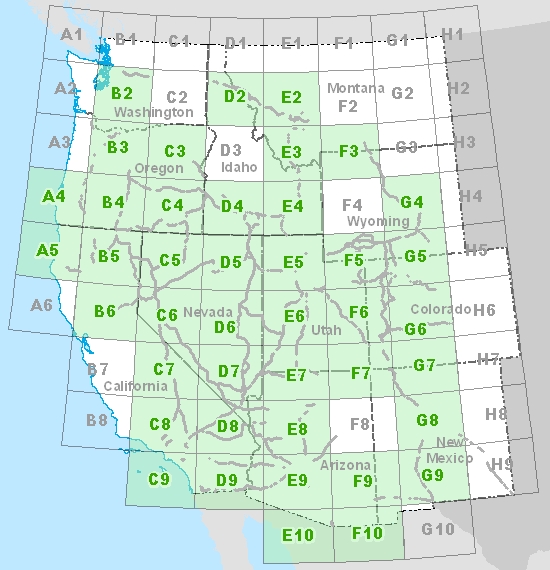
Select from Index Map
Each green-shaded grid cell in the index map below is linked to an individual visual resource analysis map for the area covered by the grid cell. Click on a green-shaded cell below to view/download the associated visual resource analysis map.
Areas covered by non-shaded grid cells do not contain selected visual resource areas in close proximity to proposed Section 368 energy corridors, thus no visual resource analysis map was prepared for these areas.
Need Help? Have Questions?
If you experience any problem downloading these files, need assistance, or have questions about the PEIS maps or mapping data, please contact the Webmaster at [email protected]